
NO PATHWAY HERE
by John H Marsh
CHAPTER IV
A NATURALIST'S PARADISE
" . . . a lovely picture. She rose, a jade jewel, out of the sea."
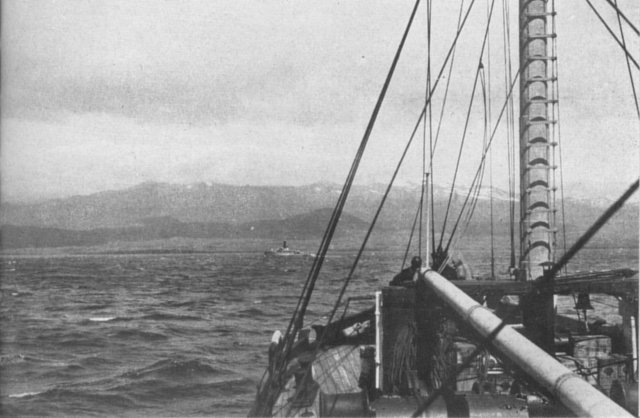
The Natal leads the store ship Gamtoos to the Anchorage in Transvaal Cove.
The noted English cartographer, Captain G. S. Nares, took the party out of Simon's Bay in the oceanographical survey ship, H.M.S. Challenger, on December 17, 1873. Among the number of eminent scientists on board was Charles Darwin, the naturalist and author of "The Origin of Species." The Challenger sighted the Island on Christmas Day and a landing was made by cutter in good weather early the next day, on the north-eastern corner of Marion Island. The cutter had great difficulty in forcing its way over the solid barrier of kelp forming a natural floating breakwater some distance from the shore.
W. J. J. Spry, one of the party, wrote afterwards : "What a scene of wild desolation and solitude met our gaze ! All around were nothing but huge blocks of rough and rugged rocks, rolled about by breakers, slippery with half-dry seaweed." The party broke up at once to explore, and very soon found its first trophy in an enormous sea-elephant. Mistaking it for a fur- seal the naturalists killed it by striking it on the nose with a stone. They desired to obtain its skeleton. Time, however, did not allow the operation to be performed.
It was soon evident that the island consisted of a lava rock base covered with a layer of decayed soggy vegetation many feet thick, with a carpet of luscious green Azorella and tussock grass as a top dressing. The ground was swampy and the going most arduous. Some of the naturalists struggled to reach the vegetation limit on the mountain slopes 2,000 feet above sea-level. None, however, were able to get within 500 feet of it. They had to climb through snow from 800 feet.
At the end of the day they returned to their ship, loaded down with trophies, and excited by their discoveries. They had found one of the few, and perhaps the main nesting and breeding places of the albatross. They had proved that the Pringles antiscorbutica (more popularly known as Kerguelen cabbage!) that saved the crews of Captain Cook's ships and others after him from the ravages of scurvy, existed here also. "A bountiful Providence seemed to have placed it there to keep away scurvy from any who might be so unfortunate as to be wrecked on its inhospitable shores," wrote Spry. They were satisfied now that Marion was entirely volcanic, presenting the usual features of volcanic islands of considerable age. They had found 15 different kinds of vascular plants and nine of flowered plants, all the latter being identical, as they discovered later, with species growing on Kerguelen. The flora of the island appeared most nearly related to that of the Falklands and Tierra del Fuego, 4,500 miles to the west. Moseley, one of the naturalists, concluded that the main part in diffusing these plants from the Falklands and Tierra del Fuego had been played by the combined action of the westerly winds and the Antarctic drift current, which, fusing with the Cape Horn current, could have carried them all this way eastward. He had noted, however, that most of the bird species inhabiting the island were of widely wandering habits. They, too, may have transported seeds attached to their feathers or feet.
To the Challenger the naturalists brought back three species of herbage; 31 of mosses, of which five were new; five of fern; and some lichens. They had evidence of the existence on the island of sea-elephants, sea-leopards, and fur-seals. They had seen three kinds of penguins-the King, the Gentoo and the "Rock-hopper". They had encountered (and been attacked by) the savage Skua gull, which fears neither bird nor man. They had found terns, petrels, shag, cormorants and a new species of bantam-like bird which they named chionis minor marionensis (laymen now just call it the Sheath-bill, or Pilot Bird!). They had even found a fly with rudimentary wings.
While her party were ashore, the Challenger had been dredging and trawling in the channel between the islands, and round the coast of Marion. She had brought up only one large fish, which was not a new species, besides some immense crabs which came up from a depth of 300 fathoms.
All the time, while cruising round, the survey ship had been taking regular soundings with her deep-sea lead and making a chart of the coastline of the island. After her party had returned on board she continued this work. Before she left the islands a few days later, she had circled both of them and compiled the chart which is to-day the only one available to mariners. That it is neither complete nor accurate in all respects is not the fault of her cartographers. They did a fine job with the equipment available and the limited opportunity they had of using it. But the Admiralty Hydrographer who accepted their chart as the official one of the islands takes care to warn mariners not to place too much reliance on it!
During his circuit of the islands Captain Nares was able to make a rudimentary topographical survey of them. He fixed the position of the centre of Marion Island in latitute 46 53 S., longitude 37 45 E.; and that of Prince Edward Island in latitude 46 36 5., longitude 37 57 E. He differed from the positions given by Captain Cook by only two miles. Marion he worked out to be approximately 12 miles long in an east-to-west direction, and seven miles wide, with a maximum height of 4,200 feet. He estimated its circumference at 33 miles, and its area at 70 square miles. Prince Edward Island he found nearly circular, 15 miles in circumference, 16 square miles in area, and 2,370 feet high.
Soundings show that both islands slope steeply under water toward the sea floor. Within 20 miles of their coasts, all round, is a depth of at least 1,500 fathoms, or nearly two miles. The southern side of Marion slopes even more steeply than the others and within two miles of the shore, not far from Cape Crozier, a sounding of 896 fathoms, or more than a mile, was obtained.
After leaving the Prince Edward Islands, the Challenger was to discover, through her soundings, the Kerguelen Plateau, forming the common foundation of all the islands to the south of the Indian Ocean.
The discovery of the Kerguelen cabbage on Marion (and later on the Crozets) was of considerable scientific importance, because it undermines a theory put forward by evolutionist Darwin to account for the transport of seeds and stones to Kerguelen and other lava islands. He held the view that these must have been carried there by floating ice, possibly assisted where the seeds were concerned by birds. It had been satisfactorily established that the natural home of the Kerguelen cabbage was the island after which it was named. Nowhere else does it grow in such profusion. The discovery of it on the islands to the west ruled out the possibility of the seeds having been carried to them by ice, for the prevailing winds and currents would prevent ice drifting in that direction. The seeds seem also to be too perishable to be transported undamaged by birds. But now the Challenger's discovery of the submerged Kerguelen Plateau gave strong support to the theory expressed by Sir Joseph Hooker after his cruise with Sir James Clark Ross, that in ancient times there had been a land connection between the three groups of islands. He considered it likely that a complete chain of giant mountains had subsided beneath the sea, leaving only its highest peaks emerging from the sea to form the island groups. The discovery of the antiquity and denudation of the lavas forming Marion, and their similarity with conditions at the Crozets and Kerguelen, lend further support to Sir Joseph's theory.
The Challenger's party had hoped also to explore Prince Edward Island, but the elements ruled otherwise. A gale came up and kept them at arm's length until they lost patience and squared away eastward toward the Crozets, following in the tracks of those who had gone before. To this day Prince Edward has not played host to scientists, and it remains virgin territory upon which discoveries of scientific importance may yet be made.
Despite all the valuable knowledge that had accrued from her visit to that area, the Captain of the Challenger felt it his duty on his return home to issue the following warning to mariners who might plan a visit to the vicinity of the Prince Edward Islands:
"The prevalence of fog and mist not only renders the islands difficult to see but also prevents the position of the vessel approaching them being ascertained with certainty . . . It is therefore advisable to avoid their neighbourhood unless some considerable object is to be gained by visiting them."
Copyright Mike Marsh (2025)